
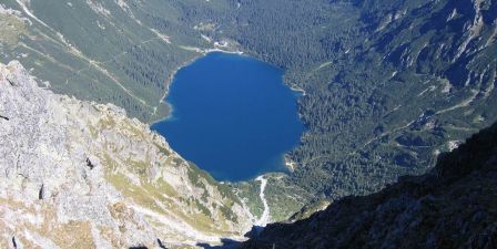
Eye of the Sea (Sea słow. eye, German Fischsee, Meerauge, węg. Noise-it) - the largest lake in the Tatra Mountains, located in Valley Stream Fish-Mięguszowieckich foot Peaks at an altitude of 1395 m above sea level
It is a lake of glacial origin of a karowo-moraine. Fills the hollow rock by glaciers bowl, closed from midnight bolt, which is the shaft end moraine. Eye of the Sea has an area of 34.93 ha, length 862 m, width 568 m, and its deepest reaches 50.8 m (wig measurements from the end of April 1934 at the very high water levels in the calculations of Joseph Szaflarskiego). Recent poll conducted by Adam Choiriski determined the depth of 51.8 m [2]. The oval shape of the lake usypiskowe cones disrupt somewhat larger at the mouth of gullies: Marchwicznego, Frog (White Piarżek), and especially Wide Żlebu (Small Piarżek, often called the peninsula of Love). From the south, the walls Mięguszowieckich Cubryny Peaks and piling up, partly overgrown with dwarf pine, massive debris cones, called together the Great scree. Lake bottom is strewn on the banks of boulders, gravel and sand below, and below about 40 feet a layer of brown silt, with the remains of vegetable and animal, with thickness up to tens of centimeters. Average gradient of the slopes below the water surface is 15 ° 20 '
The water is light green (stage IV-Forel scale Ulego), and its transparency, researchers assessed at 11 (Joseph Szaflarski) to 14 m (Ludomir Sawicki). There are clearly separated by a layer of water, so called. thermocline. Measurement carried out August 2, 1937 showed that a well-mixed by the upper layer of water waves had a thickness of only 3 m and the temperature 12.1 ° C. To a depth of 10 m temperature dropped by almost 1 ° C / m, from 10 to 20 m much less (about 0.25 ° C / m). Below 20 m, down to the bottom, the temperature was already fixed (approximately 4 ° C). Lake usually freezes over in November, the first cut in May, but there are large differences in individual years. For example, in winter 1950/51 Sea Eye frozen until January, and stajało in March. Since 1971 every year are carried out measurements of the ice on the lake. They show that both the length of the ice-Marine Eye, and the maximum thickness of the ice sheet show a downward trend. In the years 1971-1982 was the Sea Eye icy average of 171 days a year, on average, appeared on November 20, disappeared on May 9, and the average maximum ice thickness was 72 cm. In the period 1995-2007 ice persisted for an average of 157 days, on average, appeared on December 5, disappeared April 25, and the average maximum thickness was 56 cm.
Sea Eye Lake, formerly known as Fish or Fish Pond, as one of the few naturally stocked lakes in the Tatra Mountains. Powered by two permanent streams: Czarnostawiańskim Stream, that flows and cascades Czarnostawiańskiej Siklawy Mnichowym Stream, creating a dual Siklawa. Flows into the lake and several streams periodically, such as with broad and Marchwicznego Żlebu. Fish pond with flowing stream, poured out in the initial episode in a few fish Stawków: Small Sea Eye, Frog Eye, Little Frog's Eye.
On the moraine of the lake from the north wind is PTTK shelter. Located at an altitude of 1405 m above sea-level one of the oldest and most beautiful Tatra shelters. Named was named Stanislaw Staszic, who in 1805 explored the lake. Next door, at the end of the road on the left is the old shelter, which was originally coach house (1890). Both buildings are considered historic. The hostel is the starting point for excursions to the Cracks of Chlopkiem Mięguszowiecką Pass and Pass Szpiglasową.
Beyond the Sea Eye, to the south is the second large lake in the Valley Stream and Fish, Black Pond at Rysy (Black Pond on the Sea Eye). Above these two ponds ascend peaks
from the east:
Seven grenades, Nizhny Frog Peak (2098 m), Frog Monk (2146 m), Frog Doll (2095 m), Lower Cracks (2430 m)
from the south and south west:
Cracks (2503, Poland 2499 m) - highest peak in Polish, Frog Horse (2291 m), Frog Turnia Mięguszowiecka (2336 m), Beef ridge, pulpit Mięguszowiecka (2159 m), Mięguszowiecka Black Peak (2410 m), intermediate peak Mięguszowiecka (2393 m), Mięguszowiecka Grand Summit (2438 m), Cubryna (2376 m), Monk (2070 m)
from the west:
Szpiglasowy Peak (2172 m), Copper (2233 m), Tanned Peak (2115 m)


 PL
PL EN
EN DE
DE