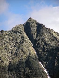
Massif drawing contains three vertices. The highest of them (the middle - 2503 m asl) is situated on the Slovak side, as the lowest tip of south-east (2473 m). The Polish-Slovak border is the average height, north-western tip height of 2499 m above sea level, which is the highest point of Polish.
Located in the High Tatras mountain range Rysy lies southeast of the Marine Oka zwornikowym point of the main ridge of the Tatras and the ridge extending from the north, which lie Nizhny Scratches and frog tops (Vyšné and Nizhny). At the foot are: Fish-Brook Valley, the Valley and the White Water Valley Mięguszowiecka. From the north it is separated from the Niżnich Rysy Rysy Pass, west of Frog Frog Horse Pass and the south-east of the massif of Heavy Summit High wide saddle weights. On the eastern side descends from Rysy 500-meter high rock wall in which there are many climbing routes.
In the western ridge above Żabia Pass Rysy be distinguished in three tournaments over the frog Saddle: Western Saddle Turnia the frog (the frog veža Západné sedlom), Intermediate Turnia Žabie Pass (Prostredná sedlom veža the Frog) and the highest Turnia Žabie East Pass (Východná veža the frog sedlom). The north-west peak Rysy turn are separated by jumper on Turniami (Štrbina over vežami). Jumper between the two higher peaks Rysy called Przełączki haunches in the features (no Priehyba Rysoch v), and between the highest and lowest tip of the jumper is implicit in the features (Prostredná Priehyba Rysoch v). To the southeast of the lowest top of the ridge directed through the front jumper in the features (Predná Priehyba Rysoch v) to sixty on the importance, and then falls on the scale
Cracks name comes not, as commonly believed, from the oblique żlebu visible in the mountain massif (the cracks), but the slope of the complex pożłobionych Niżnich features, Frog, and Frog Peak Wyżniego Monk. Later this name was adopted for the summit, which called it today. It is truly unique when it comes to rich flora, at an altitude of 2483-2503 m there are still 63 species of flowering plants, mainly from a group of alpine plants. With rare plants occur m, et al. ukwap Carpathian, and swamp saxifrage odgiętolistna Tatra - species occurring in Poland only in the mountains and on a few places [3].
Features belong to the Crown of Polish Mountains, the Tatra Mountains and the Crown Crown Europe.
The first recorded entry:
summer - Eduard Blásy guided Ján Ruman Driečnym older July 30th, 1840
winter - Theodor Wundt guided Jakob Horvayem April 10, 1884
Ascent Blásy'ego commemorated plaque to the north-western tip in 1891, but it was broken a year later. Just stay honored Vladimir Lenin (some doubt in the entrance) at the top in 1913-1914. And this board has been repeatedly destroyed. In 1899 he went to the top of the Maria Sklodowska-Curie and Pierre Curie. 28 January 2003 at around 11 Rysy went in with an avalanche, which killed 8 people with 13-person group. It was a trip of members of the Students' Sports Club 'Division', operating at Secondary School in Tychy. The accident was so tragic event in the Polish Tatra Mountains.
Scratches are the most visited Tatras mountains. Input from the Polish side is well-insured (360 meters chains), however, requires the preparation of the tourism and conditioning. From an average gradient of the Black Pond Trail is as high as 30 degrees, measured from the Marine deniwelacja Oka exceeds 1,100 meters. The trail leads through shady places, this causes the temperature drops and the high probability of residual patches of snow.
Peak of its popularity is due unrivaled panorama. On clear days you can count on the top of peaks around 100 and see even distant about 90 km Krakow. The summit, despite a considerable height is a convenient transition from the Sea eye to Poprad Valley Pond in Mięguszowiecka. The limit may be exceeded from 16 June to 31 October - for only in this period, the trail is open on the Slovak side. After the Polish and Slovak Republic to the Schengen zone in 2007 was liquidated tourist border crossing on the features, because under the provisions of the borders of the Schengen system at any location can be easily exceeded.
Scratches are the highest point in the mountains, which leads to a hiking trail. In the period November 1 - June 15 from the Slovak trail is closed.


 PL
PL EN
EN DE
DE