
Red Wierchy (słow. Červené Hills [1]) - the mountain range is located within the main ridge of the Western Tatras. He runs the Slovak-Polish border. It is located on valleys: Peaceful, Tomanowa, Tomanowa Liptovska, Kondratowa, Little Meadows and Miętusia and Kościeliska.
Red Wierchy consist of four peaks. From west to east they are:
Ciemniak - 2096 m
Krzesanica - 2122 m
Małołączniak - 2096 m
Kopa Kondracka - 2005 m
They are separated by three passes:
Slurry Pass - 2067 m above sea level, between Ciemniakiem and Krzesanicą
Litworowa Pass - 2037 m, between Krzesanicą and Małołączniakiem
Małołącka Pass - 1924 m, between Małołączniakiem Kondracka and Bras.
From the Red Hills to the north ridge deviates more. These are: the branching off of the back kulminujący Kopy Kondracka in Giewont, Red Ridge, Goat Ridge, and the longest ridge running from the Lean Ciemniak Turnie and Upłaziańską Upłaziańskiego Kopa to rhyme. On the south side was broken Krzesanicy deviates from the ridge, while the west Ciemniak: High and Tomanowy ridge. The main ridge Ciemniaku changes the direction of south and descends through the tables to Tomanowa Pass.
Construction of the Red Hills is geologically quite diverse. The core of the massif is composed of sedimentary rocks (limestones and dolomites of the Middle Triassic), and the tops are covered with a mantle of crystalline rocks (granites and gneisses). Under the gables are glacial cirques. The Red Hills massif there are many caves, including the largest in the mountains:
The Marble Cave
A small cave in the mud
Cave Miętusia
Snow Well
Great Snow Cave (hole United Litworowa)
High-The Cave of the Seven frets.
The name comes from the Red Hills red-brown color of their slopes, which gives them a plant called skucina sit in the autumn, and often as early as mid-summer red staining. In addition to the pitch creates a double-breasted and Kosmatka boimka brown. In view of the diverse geological background is very diverse species or vegetation Red Peaks - both plants grow here wapieniolubne and acidophilic plants.
For the first time of the peak heights measured in 1838 barometrycznie Zejszner Louis, he also first described the geological structure. A more modern development of the project made after Ferdinand Rabowski. Comprehensively investigated and inventoried the rich vegetation in the years 1923-1924. Examination of numerous caves initiated in 1912 Mariusz Zaruski, descending to the cave was broken to a depth of 45 m
Red Wierchy were formerly grazed, and that the way to the mountains, from the Polish side, they included a part of Little Meadow Hall, Hall and Hall Upłaz Mietusia.
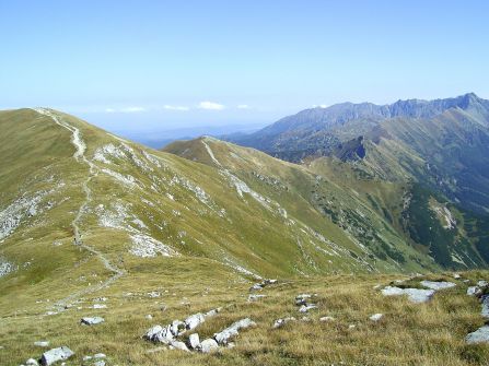
With the entire length of the exposed ridges and summits of the Red Hills offers extensive views. The peaks and ridges of the Red Hills are relatively easily available in high season for tourists do not pose technical problems. There are grassy, smooth and rounded, while below the slopes steeply usually ends clipped, kilkusetmetrowymi cliffs, which caused numerous casualties among tourists. Red Wierchy a tricky area, especially in winter and in the fog, because it threatens the loss of orientation, getting lost and increases the risk of an accident.
source: wikipedia


 PL
PL EN
EN DE
DE